The development of the road system through Hartpury.
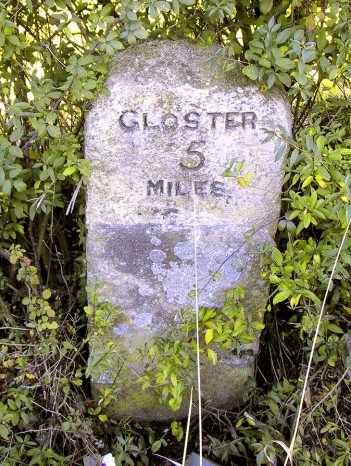 Turnpike trustees were required to erect milestones to assist travellers. The earliest were usually of stone and placed square to the road. As traffic increased, they became angled towards the approaching stagecoach. There are many local variations of stone and designs. Roman numbers appear on earlier stones, giving way to Arabic later; and misspelling and error is also an indicator of age. There are also examples of illiteracy with spacing of letters – this usually improves with the metal posts.
The use of stone was common, because it was a relatively inexpensive material, although some were replaced by metal when industrialisation made metal cheaper. Many metal plaques were attached to older stones covering their existing markings.
In 1888 when the new (then) county councils became responsible for the highways, the ownership of the markers passed to them, and they began to restore the routes where stones had become illegible or disappeared altogether.
The ancient settlement around Hartpury church is a quiet backwater today, but this had not always been the case. It was once a principal route to the west. As the earliest inhabitants settled in farming communities, trading between them evolved. The very name Morewent, a hamlet in Hartpury, was derived from the Celtic maro and Romano-British venta, meaning ‘great market’, suggesting that it originated as a trading centre where the tracks converged close to the lowest fords over the rivers Severn and Leadon.
Soon after their arrival, the Romans built the causeway west from Gloucester across the marshy river valley and probably bridged the river Leadon at Over. At that time there was no western branch of the Severn. Use of the ford at Maisemore would have declined and a new route may have developed through Lassington, fording the river Leadon at Rudford to connect with the old road at Morewent – a further explanation for the existence of the settlement. From Morewent one road, passing near the present church in Hartpury, led eventually to Hereford, while another ran through Upton-on-Severn to Worcester. It was only when Maisemore bridge was built around 1200 that the much earlier route through Maisemore would have returned to regular use. The importance of this bridge to medieval trade is shown by the numerous Wills leaving sums for its repair (for the ‘mayntynance of Maysmor bridge 2s’ in 1545, and ‘2 bushels of wheat for the rep’n of Maysmore bridge’ in 1547). In medieval times merchants, who travelled around the country, were very aware of the deficiencies of the highways, and so frequently left bequests of this kind.
1726 saw an Act of Parliament for the repairing and widening of the roads from Gloucester. This empowered trustees to improve various roads and authorised the charging of tolls for their use. One combined the ancient routes through Hartpury to Upton (and Worcester), and to Ledbury (Malvern and Hereford). They ran together to Crosshands, Corse (which was then the start of uncultivated Corse Lawn) where they split as they do to the present day. Following the creation of the turnpike through Hartpury, the modern village centre developed along the new road in the hamlet known as Corsend.
Patterson in his map of 1789 mentions only the road to Malvern as passing through Hartpury, the road to Hereford going by way of Ross. By 1792 he shows a road from Gloucester to Kidderminster which reaches Corse Lawn 4 miles from Gloucester, presumably the Woolridge common in Hartpury was then considered a part of Corse Lawn. Cary, in 1791, gives the route through Hartpury to Hereford (by Woolridge Hill and the Crown, later the Canning Arms). In 1822, Patterson shows the same road, but a new road from Maisemore through Overton to Hartpury was constructed in the early 19th century, and by 1828 this improved route appears to have replaced the old road over Woolridge. 1822 also saw the construction of a new bridge over the Severn at the Haw, by the Haw Bridge and Roads Turnpike Trust, which became another contender for the London to Hereford traffic.
The importance of these roads is illustrated by the turnpike through Maisemore to Over being the last of the turnpikes around Gloucester to be abolished (1st November 1879). A final year’s extension had been granted in 1878, on the grounds that the traffic was far more than the average and that it would be unfair for the parish to have to make good the wear and tear. In 1888 the Local Government Act transferred responsibility for main roads to the newly formed County Councils.