Milestones on A40 – B4215
The stones on this route probably date from 1749. It was in that year that the trustees ordered them to be laid from the Smith’s shop at Over to Newent. Only two with any readable markings have been found . These have Roman numbers – with the 4 miles mark being written as IIII which agrees with the early date. This is similar to many of the other early routes in the country. All the others except one are missing, but this road has been considerably re-aligned over the years, (beginning in 1726!), so they could well be there but on private tracks and lanes.
The turnpike date for this route is 1726.
| OS / Location | Dimensions | Image | Notes / Comments |
|---|---|---|---|
| SO810195 Over Right MS |
75x37x32 | 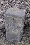 |
I Once painted ‘yellow’ below line |
| c. SO796198 Highnam MS |
Not found | ||
| c. SO785209 Rodway Hill MS |
Not found | ||
| SO773220 Barbers Bridge (old road) Left MS |
84x36x24 |  |
IIII Limestone |
| SO766235 Highleadon Left |
54x34x25 | 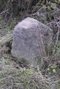 |
Very eroded No visible markings |
| c. SO757247 | Not found | ||
| c. SO738254 | Not found |